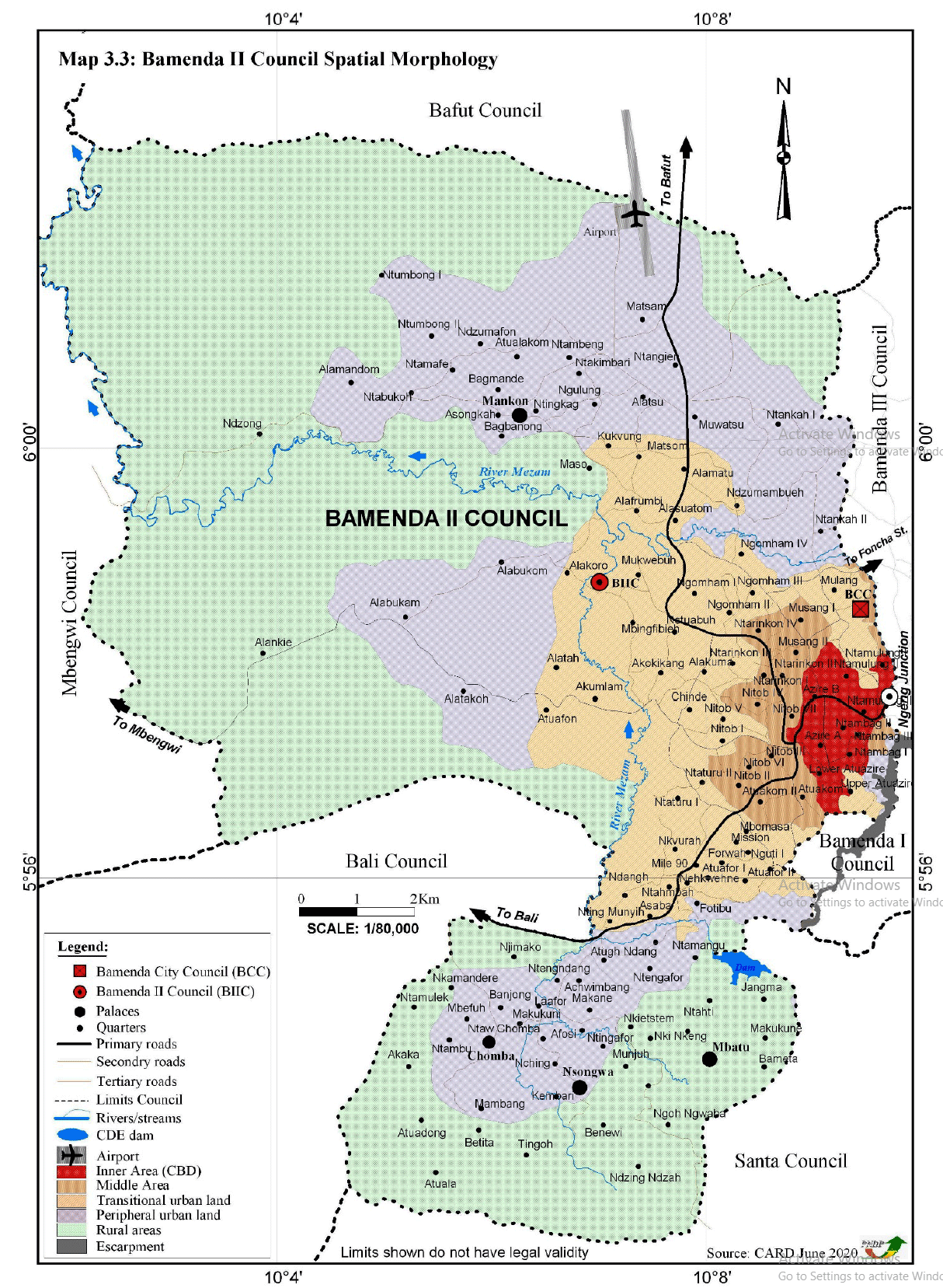
Bamenda II Council had experienced spontaneous growth, with a few layouts dated back in 1940 in a traditional grid iron pattern specifically at Ntambag and the Fon Street Layout. These layouts had limited provision of public services, and restricted mobility. Today the areas had grown to form a central core of the city as a result of urban growth factors mentioned above.
The spatial pattern of the town is more of, the core‐periphery pattern whereby, the high and middle‐income groups are concentrated in the central areas of the town while low‐income groups live on the outskirts. This is almost the reverse of the pattern of Western cities, where higher incomes are located in low‐density areas in the outskirts and lower‐income groups live in the urban centre. Also, the urbanization process lacks insufficiently planned and poorly coordinated-resulting to overcrowding in certain parts and leaves unused land in others. The partial upgrading of settlements areas of Ntambag (Old Town) and Lower Atu-azire resulted in the changes not only in the quality of space, which is provided by urban services and infrastructure, but also brings about a morphological evolution; thus imposing an urban form that has grown organically, and incrementally.
Direction of Urban Expansion: The expansion of the urban space is unprecedented and has no pattern. The main directions of urban expansion are influence by the major entering and exit points. For the Bamanda II Council, the major entry and exit points of the area are: Bali road, Mbengwi road, and Bafut road. These roads are more accessible and have attracted many developers towards that direction. Other driving forces include:
- The pattern of land suitable for construction;
- Availability and easy access to cheap land towards the urban periphery;
- The easy access to water and electricity supply;
- The pattern of the location of public and community facilities such as schools, markets, and lorry parks;
- The pattern of the location of public offices; and
- The preferences of residents to locate along the main directions to their villages and divisions of origin.
Bamenda II Council Spatial Structure
Spatial structure is the organisation of urban units into a system of places, which serve different functions or have different land uses, which are linked by networks of physical and/or non-physical flows of persons, goods, services, and information. The urban area of Bamenda II Council has some of these elements mentioned proposed in its POS. But the existence of these is not as the result of a conscious and deliberate effort to make the town work or function efficiently and effectively.
Indeed, some quarters and some streets in Bamenda II Council have names; even some houses and some plots equally do, all done by individuals or as a result of an event which should not be the case. In planning terms, Bamenda II Council can be described as partially organized:
- Organised: because Ntambag, Mulang, Ngomgham, Fon’s Street area have layout and show an orderly pattern.
- Disorganised: in the traditional and native areas where the indigenes are settled and where present population growth and pressure on the land has compelled urbanisation of the land without prior servicing with roads, water, electricity or drainage. A substantial part of Bamenda II Council falls under this category.
However, the town has a dense inner area that has a Central Business District (CBD), complete with financial institutions, stretched along the main streets, and around the market area.
The Bamenda II Council Land Use Plan (LUP) adopted an urban spatial structure in line with the direction of urban expansion which ensures:
- The systematic conversion, planning and rational development of lands in the fringes of urban areas to minimise urban sprawl and anarchical land development and the construction in peripheral zones;
- The progressive infilling of vacant plots in inner areas and the middle
- belts and lastly; The encouragement of the construction of high-rise buildings where and when necessary.
Clear hierarchies of road networks were to be developed providing choices of routes from all directions and reducing traffic through the city centre. In addition, a coherent hierarchy of urban spatial structure with service centres were to be developed to minimise the need to travel to the city centre.
Internal Spatial Structure
The internal spatial structure of urban space is overwhelmed by commercial and residential land uses. Commerce was and is the major activity that brought about the origin and growth of the city; and the CBD is the core area and falls within the startup point of the city containing- the commercial avenue and markets, financial institutions, treasury and taxation department of the region, cathedral, central mosques, regional hospital, telecommunication facilities, major hotels and major road and housing infrastructures. The five major roads into the CBD constitute shopping streets and foci points for commercial activities and the back streets are residential developments of mix, low, medium and high grade houses.
Surrounding the central business district is high density low grade residential areas; which is gradually being transformed into mix commercial and residential activities. High rise buildings with up to (G+5) storeys are gradually replacing old and dilapidated residential buildings. The rate of replacement of old and dilapidated residential buildings depend on the property market situation which is imperfect.
High density low grade residential areas are followed by medium grade residential areas which are progressively transformed into high density residential zones. Beyond this point are mix residential areas of low, medium and high income households living close to one another and their choice of location is the availability and cheap land value. This outer area is dominated by urban sprawl of low density housing emerging from the spontaneous conversion of rural land.
The internal spatial structure of Bamenda II Council is made up of: -
a) Inner Area: A densely built inner area as seen in Map 3.2 below is gradually being transformed into an area for commercial activities. High rise buildings with up to five storeys are gradually replacing old and dilapidated residential buildings. Low income high density houses are hidden behind newly constructed high rise buildings.
b) Middle Area: A middle area made up of largely low rise medium income houses. This is progressively transformed into high density residential zones.
c) Peripheral Area: An outer area of sprawling low density housing emerging from the spontaneous conversion of rural land. These areas contain rural lands which are being converted into the peripheral areas.
d) Rural area: These are lands in the rural areas of Mankon, Chomba, Mbatu and Nsongwa. Their predominant activity is agriculture (crops and livestock production). The map below shows the existing internal spatial structure of the Bamenda II Council: